| In
the valley of the Gatun River ground levels, which were from 20 to 25 feet above
sea-level, proved on examination to be composed of a mass of soft
clay, decomposed wood and vegetation, from 150 to 200 feet in
depth, resting upon a rock foundation. This mass had near the top
a hard stratum of clay and sand from 20 to 30 feet in thickness,
but the space between this crust and the foundation was filled
with soft material. Across these valleys - one of them, that of
the Gatun River, being about three miles in width - huge
embankments to be constructed, ranging in height from 58 to 74
feet. When the weight of these became too great for the crust to
sustain, it pressed that down upon the material beneath and forced
it to the surface on either side. This action added greatly to the
amount material in the embankments, for the upheavals had to be
counterweighted, virtually doubling the width of the foundations, and
the settlement of the ground surface, varying from 25 to 60 feet,
added the distance in each case to the height of the embankment
the center or road-bed line.
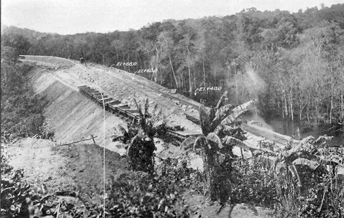
The elevations are show
in the photo as 40, 60 and 80 feet above sea-level. The white line
from where the photographer stands to the far curve will be the final
line when done. This photo is another great example of the
magnitude of this big project.
|